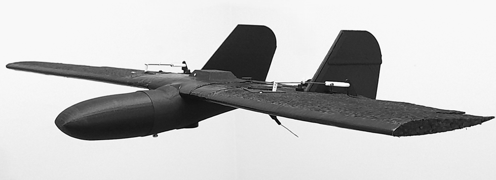
Aircraft Cartographer Mini PPK/RTK weighing less than 250 grams
Project of the Aerial Photography Complex with Open Source Software
Overview of the project
We are pleased to present you with an innovative aerial photography complex, developed for creating accurate maps of the terrain and landscape, as well as monitoring vegetation using open-source software. This complex is unique because its aircraft weighs less than 250 grams, making it extremely mobile and efficient in application.
Main components of the project:
Open source software:
OpenDroneMap: Creation of maps and topography from photographs.
QGIS: Raster transformation for vegetation analysis (NDVI).
SputnikAgro: Conversion of vegetation maps into a format suitable for sprayers and fertilizer spreaders.
rtklib: Determination of exact coordinates of the photos.
ardupilot: Control of the drone, programming flight, auto-start, and auto-landing.
Mission Planer: flight mission planning
openTX: Controller radio programming software.
Raspberry Pi OS: Recording photographs and data to calculate accurate photo coordinates.
ELRS: Two-way communication with the drone, telemetry.

Equipment package:
Aircraft Cartographer Mini PPK/RTK: Includes:
Cartographer Mini — 1 unit
Infrared filter for creating ordinary orthophotoplans — 2 units
Red filter for creating vegetation maps — 2 units
Base station RTK L1 for PPK — 1 unit

microSD card 64 GB — 2 units
3200mAh 2S battery pack — 3 units
Radio controller Pocket Radiomaster — 1 unit
Propellers GemFan 6X4 — 2 units
USB charger 5v 2A — 1 unit
Screwdriver — 3 units
Protective case — 1 unit
Drone characteristics:
Dimensions: 310×580×90 mm (L x W x H)
Weight with battery: 247 g
Maximum climbing speed: 7 m/s
Maximum speed: 20 m/s
Maximum wind speed: 15 m/s
Maximum flight time: 60 minutes
Operating temperature range: from -10°C to 40°C
Maximum flight distance: 50 km
Satellite positioning systems: GNSS (GPS, Galileo, BeiDou, GLONASS) L1
GNSS module: PX1105R L1/L5 GPS / GNSS RTK receiver for applications with centimeter accuracy.
Viewing area per flight:
2 square kilometers at a Ground Sample Distance (GSD) of 3.5 cm, a front overlap coefficient of 70%, a side overlap of 60%, and a flying speed of 15 m/s at an altitude of 120 meters.
Battery:
Capacity: 3200 mAh/h
Voltage: 7.4 V
Type: Lithium-ion battery 2S
Weight: 95 g
Energy capacity: 11 Wh
Maximum charging voltage: 8.4 V
Charging temperature range: from 5°C to 40°C
Camera:
Sensor: Sony IMX519 stacked, back-illuminated sensor, 16 megapixels, pixel size 1.22 µm × 1.22 µm
Lens: f/1.75; EFL: 4.28
Field of view: 66°(H) x 49.5°(V) x 80°(D)
Infrared sensitivity: Without an IR-cut filter, sensitive to infrared rays
Charging station:
Input: USB-C: 5 V, 2.0 A
Operating temperature range: from 5°C to 40°C
Currently, extensive flight tests are being conducted; a report on which will be published later. For easing and accelerating map creation, there is an online service available. Upload your files, and receive the map in the shortest time (approximately half an hour).
Advantages:
The weight of the aircraft allows free use in many countries without registration or permits (direct visibility, height up to 122 meters, no people in the flight zone).
Perhaps in another country you won’t have to wait months for permission to use.
Fully open-source code - security and openness.
Speed and ease of obtaining maps when using a cloud service.
Mobile usage - total weight of the kit for one working day (6 hours of flight - 12 square kilometers) is only 2.5 kg, including the aircraft, 6 batteries, radio control, smartphone, rubber catapult, and case. Dimensions: 25X40X10 cm.
For all questions, please write to: rtknavi.service@gmail.com