RTK laboratory: for precision farming.

This is for those who have a tractor with a precision farming steering device, but do not have a base station or cannot use it to implement RTK mode for precision farming.
In order for a tractor to drive accurately, it is not enough that it is prepared for precision farming. For this purpose a stationary receiver of satellite signals (hereinafter GNSS Base) is needed, which transmits information to the tractor via internet or radio modem.
The accuracy depends directly on the distance to the GNSS base. Even the best receivers have an error of 1.5 cm plus 1 cm for every 10 km to the base. So, if you find a corrections supplier (information for accurate driving) with a distance to the base of 30 km, the error will be 1.5+3*1=4.5 cm. That is 4.5cm to the left and 4.5cm to the right. The total error can be up to 9cm! Let's add the error of the tractor itself.
Thus, it is advisable to place the base as close to the field as possible!
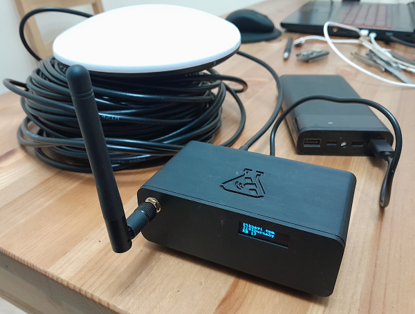
We have developed and produced the base that you can install at your place.
We send the base with presets for connection to our service.
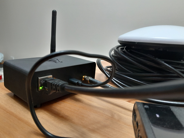
You just need to place the antenna on the roof, connect the cable to the router and supply power.
We have also provided a backup connection via Wi-Fi.
You only need to connect the base via a poverbank and place a cell phone with a configured access point nearby.
When you first turn on the base determines its coordinates approximately +-2.5 meters.
That is, if you turn off the power and turn on again, you will see other coordinates.
To achieve repeatability of results and when switching between different bases in your network should collect information from the base and send it to a special services, where using daily observations, calculate the absolute position with an accuracy of a few millimeters. That is, if you perform the calibration procedure again, the position coordinates will not differ by more than a few millimeters.
This very important procedure for achieving accuracy is done automatically by our service within 3 days.
If you already have a calibrated base at a distance of up to 50 km to the new base, it will take a few minutes to determine the exact coordinates. If you have a valley where there is no stable mobile internet, you can put the base on top where it is and transmit information by radio down to the valley. Our service will automatically determine the exact coordinates of the base.
Also on the online map you will see in a convenient form information about the work of bases and tractors traveled distance for the last time.
We use duplication in cloud servers from leading companies (only when paying for professional user connection).
You can always create and use an account for one user connection and unlimited number of bases for personal use. Experiment with settings, coordinate systems, track the quality of RTK solution, position and path of the rover on the map.
You can use your free single user connection to redirect the data stream to our free NTRIP FREE CASTER for an unlimited number of user connections.
Keep in mind that stable operation of FREE CASTER is not guaranteed and we recommend to use it only for experimentation.
If there were no user connections to the base for 4 days the base goes into inactive mode. To activate it you just need to log in to your account and click "create new settings and run caster".
The function of connecting "nearest" to the nearest available base with defined exact coordinates, which avoids "jumping" of coordinates. This function allows not to change the login and password on the tractor when adding new bases and working from them.
There is automatic detection of absolute coordinates of bases for switching between bases without loss of accuracy.
There is a convenient display on the map in your personal cabinet with the state of bases and tractor routes up to 4 days ago.
The price of professional user connection is 99USD per year - that's less than 8$ per month.
Our base model costs 590 USD.


We use the well proven PX1122R module : MULTI-BAND QUAD-GNSS RTK MODULE
230 Channel Carrier Phase Measurement RTK Receiver
Hardware Supporting:
GPS L1 / L2C
Galileo E1 / E5b
Beidou B1I / B2I
GLONASS L1 / L2
QZSS L1 / L2C
Integrated RTK, no 3rd party software needed
1cm + 1ppm RTK accuracy in seconds
Beitian High precision high gain CORS RTK GNSS antenna Support GPS Glonass Galileo Beidou Survey GNSS Antenna BT-160.
15 meters antenna cable for convenient antenna installation.
Our base has 3 ways of connection.
1-LAN wired connection - 100% stability.
2-WIFI connection to a router - 99% - breaks up to 2-4 minutes.
3-WIFI connection to a mobile access point via mobile communication - unstable-reserve variant.
Expansion modules are available: poverbank, radio modem, 2-3-4G cellular module with a powerful directional antenna.
Adding bases does not require any changes in the tractor setup, but only improves accuracy and stability!
We produce equipment as needed, so write in advance to install bases for the season of work.
You can also assemble a GNSS base station yourself using our instructions.
Contact: rtknavi.service@gmail.com